

Flanders wildfire in Crow Wing County grows to over 1,100 acres, evacuations underway
MN wildfires: Flanders fire burns over 1.1k acres
A wildfire burning in Crow Wing County has quickly expanded to over 1,100 acres on Saturday. This comes as fire crews have contained about 30% of a wildfire north of Two Harbors. FOX 9 Leon Purvis reports.
BREEZY POINT, Minn. (FOX 9) - Firefighters and aircraft are battling the fast-growing Flanders wildfire east of Breezy Point in Crow Wing County on Saturday. Officials say the fire has grown to over 1,100 acres, and evacuations are underway.
Find the latest updates below.
9:45 p.m. - Fires to be monitored overnight
The Crow Wing County Sheriff's Office said fire crews and law enforcement will continue monitoring the Flanders wildfire overnight as dangerous fire conditions remain in the area. Residents in affected areas should stay alert and be prepared for possible evacuation notices if conditions change.
"Residents who have already been evacuated will NOT be allowed back into the area until emergency personnel determine it is safe to return. This is being done to protect both the public and responding crews as fire conditions remain unpredictable," wrote the sheriff's office.
9:34 p.m. — Wildfire grows to over 1,000 acres
According to the latest wildfire maps, the Flanders fire has grown to at least 1,134 acres and remains at 0% contained. Just this afternoon, the wildfire was reported at just 600 acres.
8:50 p.m. — Shelter for people evacuating
The Crosslake Community Center has transitioned into a shelter for people affected by and evacuated from the wildfires, according to county officials.
Officials say evacuees can stay overnight at the shelter, where meals, snacks and beverages are being provided. Organizers are working to accommodate pets as families continue to seek assistance.
5:50 p.m. — Temporary evacuation point in Crow Wing County
County officials say a temporary evacuation point has been set up at the Crosslake Community Center for people impacted by the Flanders wildfire.
The shelter is located at 14126 Daggett Pine Road in Crosslake, where snacks, drinks and assistance are available for evacuees. Authorities are urging residents to continue following evacuation instructions as crews respond to the wildfire.
Flanders wildfire in Crow Wing County
MN wildfires: Crews battle Flanders, Stewart Trail fires
Firefighters are battling two large wildfires in northern Minnesota on Saturday. The Stewart Trail fire near Two Harbors is an estimated 376 acres and 0% contained. The Flanders fire in Crow Wing County has grown to 600 acres and is also 0% contained.
What we know:
The Flanders wildfire, located in Crow Wing County, is burning about 10 miles east of Breezy Point along Highway 6, according to the Minnesota Interagency Fire Center. Officials estimate the fire has grown to about 600 acres and remains 0% contained.
In a 5:36 p.m. update, authorities estimate the fire has burned an estimated 1,500 and 2,500 acres, though an exact size cannot be determined, according to Crow Wing County officials.
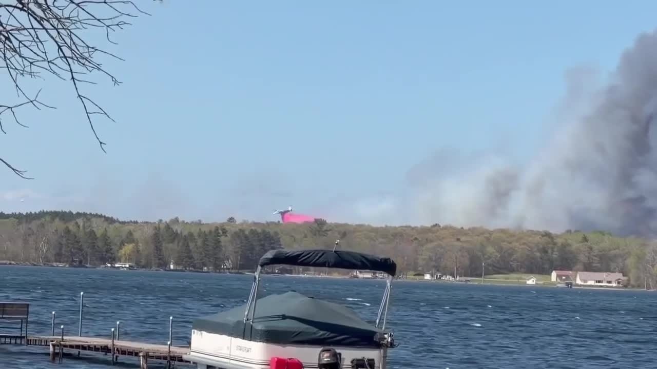
Footage shared with FOX 9 shows thick plumes of smoke rising above the trees and an aircraft dropping fire retardant near Upper Mission Lake in Merrifield, Minn.
MNICS said red flag warning conditions are contributing to the spread of the fire.

Photo from Stephanie showing a wildfire in Crow Wing County near Upper Mission Lake in Merrifield. (Stephanie / Supplied)
Evacuations and road closures
Local perspective:
County Road 11 is closed from Cross Lake, Minnesota to State Highway 6.
The Crow Wing County Sheriff's Office said in a 5:10 p.m. update that authorities are working to evacuate areas east of East Horsehoe Lake Road and south of County Road 11.
Drivers are being asked to stay out of the area when possible, use alternate routes and follow directions from emergency responders. Officials also warned people not to stop to watch the fire, citing safety concerns and the need to keep roads clear for emergency crews.

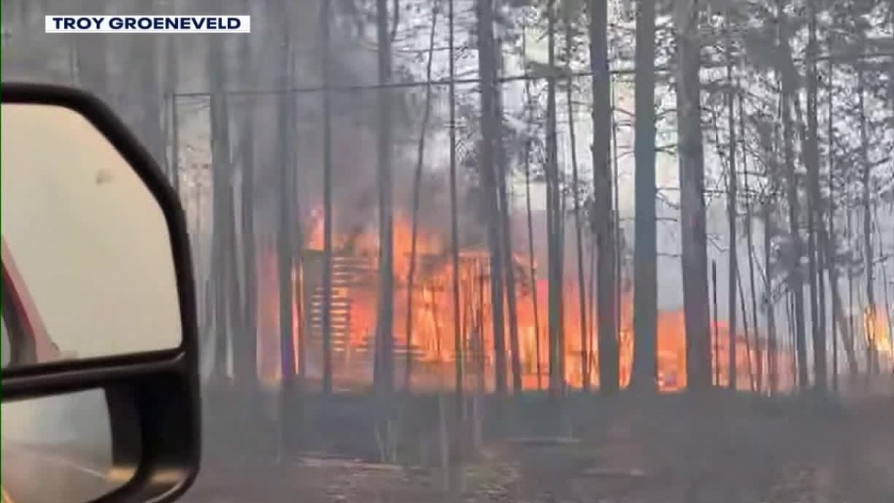
Drone footage from Breezy Point showing a wildfire in Crow Wing County. (Credit: Ryan N.) (Ryan N. / Supplied)
What we don't know:
Authorities have not said when the fire was first reported or whether any injuries have been reported.
The sheriff’s office said updates will be released as more information becomes available.
Red flag warning in Minnesota
Local perspective:
Crow Wing County is among the 15 counties included in a red flag warning issued by the National Weather Service on Saturday.
The other counties under the warning include Cass Aitkin, Carlton, St. Louis, Pine, Otter Tail, Wadena, Grant, Douglas, Todd, Morrison, Mille Lacs, Kanabec, and Benton counties.
Red flag warnings are issued when conditions such as low humidity and strong winds could cause fires to spread quickly and get out of control, according to the DNR.
What they're saying:
"When fire risk is this high, it’s important to be careful with anything could spark a wildfire," said Mike Warnke, DNR wildfire administrative supervisor.
Officials are urging residents not to burn in counties where the warning is in effect and to check any recent burning to ensure fires are completely out. The DNR will not issue or activate open burning permits for large vegetative debris burning and said campfires are discouraged.
Stewart Trail wildfire in northern Minnesota
![Stewart Trail Wildfire in northern MN: Chopper [RAW]](https://static-media.fox.com/fmcv3/prod/fts/39s76ge8n2d1nhms/yx6n0rturzggm2rv.jpg)
Stewart Trail Wildfire in northern MN: Chopper [RAW]
Crews continue battling the Stewart Trail wildfire in northern Minnesota on Saturday, as the blaze has grown to 376 acres with no containment. Chopper footage shows burned terrain and aircraft dropping water on hot spots.
Big picture view:
The Crow Wing County wildfire comes as crews are working to contain another wildfire in northern Minnesota, known as the Stewart Trail Fire.
The fire is burning about three miles north of Two Harbors, has grown to 376 acres and remains 0% contained, according to fire officials. Local fire departments are focusing on structure protection along the Highway 61 corridor, where portions of the highway remain closed due to heavy smoke and firefighting activity. Evacuation notifications remain in place in parts of Lake County as crews continue working to slow the fire’s spread.
St. Louis County wildfires
Dig deeper:
The St. Louis County Sheriff’s Office says firefighters are responding to multiple fires across the county Saturday afternoon as dry, windy conditions increase wildfire danger in the region.
Crews are battling a structure fire in Lakewood Township while working to prevent it from spreading into nearby woods. Firefighters are also responding to a wildfire in New Independence Township near Erickson Road and Highway 53, as well as additional wildfires in Fayal Township and the Maple Drive area in Biwabik Township, where air units are assisting crews on the ground.
Authorities said residents will be notified if any fires begin threatening homes or communities and urged people not to burn outdoors Saturday.
The Source: This story uses information from the Crow Wing County Sheriff's Office, National Weather Service, and St. Louis County Sheriff's Office.