

MN weather: Storms cause flooding, damage along MN's North Shore
MN's North Shore cleaning up after flooding, storms
FOX 9's Rob Olson has the latest on the cleanup on the North Shore after severe storms caused flooding in Northeastern Minnesota.
TOFTE, Minn. (FOX 9) - Storms battered northern Minnesota and areas along Minnesota's North Shore on Tuesday, leaving plenty of damage in their wake.
Rain caused flooding, washing out streets, and strong winds downed trees. Here's a look at some of the damage in Northern Minnesota and along Minnesota's North Shore.
READ MORE: Rain totals: Heavy downpours cause flooding in northern Minnesota
Minnesota state trials, areas of parks closed
Raging Gooseberry Falls after recent storms
This video from Jayson Hansen shows raging Gooseberry Falls after recent storms on the North Shore of Lake Superior as of June 19, 2024. (This video is looped)
Recent rains have prompted the Minnesota DNR to close some state trails, campgrounds and areas of state parks.
In a post on Facebook on Wednesday, the Minnesota DNR said "We are closing a number of trails, campgrounds and portions of parks due to high water conditions and risk of flooding. Tours at Soudan Underground Mine have been suspended, and the Eckbeck and Finland campgrounds in the Finland State Forest are closed."
You can find a list of park closures here.
Meanwhile, there are reports the popular suspension bridge over the Baptism River at Tettegouche State Park has been taken out by flooding. The bridge was closed in 2022 after being damaged by flood waters but it was still standing until Tuesday's storm.
St. Louis River above flood stage
St. Louis River levels rising near Duluth, MN
The St. Louis River and other rivers in Northeastern Minnesota are high and are continuing to rise after severe storms Tuesday night that caused flash flooding on Minnesota's North Shore. Here's a look at the St. Louis River at Jay Cooke State Park near Duluth, Minnesota.
The Upper St. Louis River, which flows through Jay Cooke State Park near Duluth, has crested and is above flood-stage level due to all the rain causing it to swell.
Flooding was also reported in Duluth.
Storms cause flooding in Duluth
Tuesday storms that caused damage across Northeastern Minnesota caused flooding in Duluth. This video was taken by John Keefover, who described the flow of water as "Class 5 rapids" outside of his apartment. In a Facebook post, Keefover said, "This same culvert that diverts water underground by Whole Foods backed up like this in September as well as back in 2012 during the major flooding." (This video is looped.)
Bluefin Bay on Lake Superior sees flash flooding
Flooding at Bluefin Bay on Lake Superior in Tofte
Videos taken by Jayson Hansen show the extent of flooding at Bluefin Bay on Lake Superior in Tofte, Minnesota, Tuesday night amid severe storms that included heavy rainfall on Minnesota's North Shore.
Tuesday's storm caused fast-flowing water to run into Lake Superior at Bluefin Bay on Lake Superior in Tofte, flooding part of the beach. Jayson Hansen shared the video above with FOX 9, showing the extent of the flooding.
Meanwhile in Tofte, a possible water spout was spotted on Lake Superior. This has not been confirmed as a water spout though.
Lake County road washed out
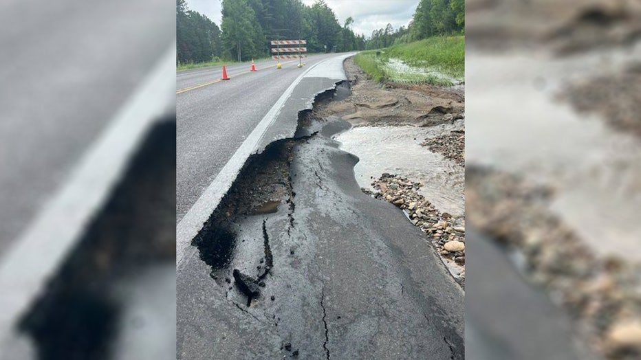
A washed out Highway 2 in Lake County, Minnesota, on Tuesday, June 18, 2024. (Lake County Sheriff's Office)
The Lake County Sheriff's Office is reporting at least one washed-out road, on Highway 2, about 2–3 miles north of Forest Highway 11. The sheriff's office says part of the road there is gone, and crews are working to determine damage and signage.
On Tuesday night, the sheriff's office encouraged people to stay off the roads.
Flooding in Hibbing, issues in St. Louis County
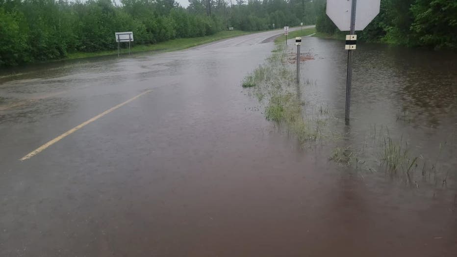
County Road 63 in Hibbing is flooded. (St. Louis County, Facebook)
Meanwhile, in Hibbing, Highway 169 was also swamped. A photo shows a significant amount of water accumulating on the roadway Tuesday, and a police car blocking traffic from the danger. Meanwhile, County Road 63 was also flooded in Hibbing, St. Louis County officials said.
Giants Ridge Road in St. Louis County also became washed out.
READ MORE: Storms cause damage and flooding in Duluth, prompt road closures in Northland
Giants Ridge Road in St. Louis County. (St. Louis County, Facebook)
Officials in St. Louis County say the rain has caused "a lot of damage" across the area, noting public works crews worked late Tuesday night and started working again early Wednesday to assess the damage, posting signs and beginning repairs. The county says it will post a list of road closures as soon as possible.
Roads closed in St. Louis County
St. Louis County is anticipating an emergency declaration after heavy rainfall Tuesday night, with the sheriff's Emergency Management Division in communication to being the process of gathering damage assessment estimates.
"It is anticipated the St. Louis County Board will approve a disaster declaration at its meeting next week, a necessary step the county to seek funding assistance from the state and FEMA on behalf of itself along with cities, townships, unorganized areas, and public utilities within the County," a press release Wednesday states.
St. Louis County Public Works is in the process of assessing infrastructure damage and is making repairs, with the focus on reopening roads that have kept people without access to and form their homes, the release says.
Among the roads that are closed is Mud Creek Road near Lake Vermillion, where "water levels remain too high to attempt repairs." The sheriff's office has made a "contingency plan" should anyone need emergency services.
Mud Creek Road northeast of Lake Vermilion has washed out, and water levels remain too high currently to attempt repairs, according to St. Louis County. (St. Louis County)
The northern third of the county sustained the most damage, a press release says. County officials say 43 county roads are closed, 32 of which are in the northern portion of the county. Here's a list:
Northern St. Louis County:
- Hwy 22 (State Hwy 53 – County Road 912 Ralph Rd)
- CR 652 Goodell Rd (State Hwy 53 – County State Aid Highway 82 Heino Rd)
- CR 467 Heino Rd (State Hwy 53 – CR 912 Ralph Rd)
- CR 912 Ralph Rd (CR 652 Goodell – CSAH 82 Heino Rd)
- CSAH 24 Crane Lk Rd (Unorganized Township Rd 8121 Kallio Rd – CSAH 23 Buyck)
- CSAH 24 Kallio Rd (UT 8121 South – UT 8121 North)
- CR 512 Sassass Rd (CSAH 87 Leander Rd – Terminus)
- CR 421 Sassass Rd (State Hwy 1 – CSAH 87 Leander Rd)
- CR 912 Ralph Rd (CR 467 Heino Rd – CR 492 E Anton Rd)
- CR 492 E Anton Rd (CR 912 Ralph Rd – State Hwy 53)
- CR 467 Heino Rd (State Hwy 53 – CR 430 Burghardt Rd)
- CR 936 E Hannula Rd (State Hwy 53 – Terminus)
- CR 481 Carpenter Rd (CSAH 82 Heino Rd – CSAH 22)
- CR 923 Leander Rd (CR 912 Ralph Rd – Terminus)
- CSAH 22 (State Hwy 73 – CR 931 Murray Rd)
- CSAH 25 (CSAH 65 – CSAH 22)
- CSAH 107 Lind Rd (UT 8199 Range Line Rd – State Hwy 73)
- CR 931 Murray Rd (CSAH 22 – CR 491 Gustafson Rd at Bridge)
- CR 481 Carpenter Rd (UT 8163 Graham Rd – UT 8157 Goodell Rd)
- UT 8157 Goodell Rd (CR 491 Roini Rd – State Hwy 73)
- CR 492 Anton Rd (west of State Hwy 73 from Fire # 11244 – Terminus)
- UT 8134 West Reik Rd (Ut 8142 – CSAH 139)
- CSAH 114 West Olson Rd (CSAH 5 – State Hwy 73)
- CSAH 139 Range Line Rd (State Hwy 1 – CSAH 114 West Olson Rd)
- CR 720 Lindsey Rd (State Hwy 1 – CSAH 114 West Olson Rd)
- CSAH 116 Echo Trail (UT 8211 North Arm Rd – Moose River Landing)
- UT 8211 North Arm Rd (CSAH 116 Echo Trail – Terminus)
- CR 455 Sundling Rd (CR 676 Fectos Rd – Terminus)
- CR 674 Breezy Pt Rd (CSAH 77 – Terminus)
- CR 949 Bradley Rd (CR 929 Moccasin Pt Rd – Terminus)
- CR 408 Mud Creek Rd (State Hwy 1/169 – Terminus)
- CSAH 138 Giants Ridge Rd (CR 416 Tower/Biwabik Rd – Terminus)
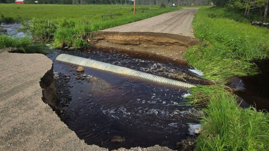
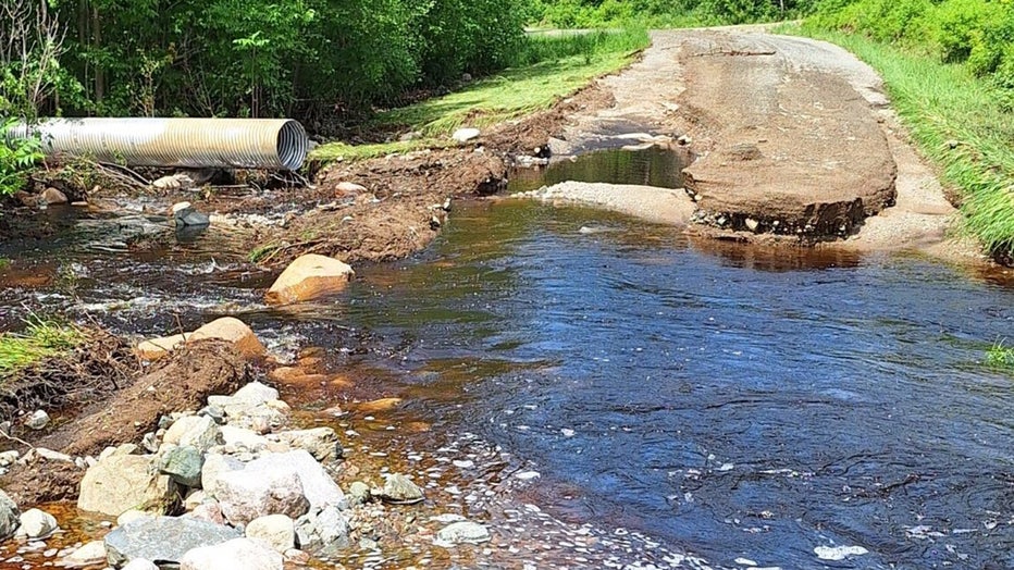
Heavy rains and high water washed out this culvert in Linden Grove Township near the intersection of Lind Road and Range Line Road, according to St. Louis County.
Duluth and surrounding townships:
- Fox Farm Rd under water at Sucker River Bridge between Two Harbors Rd and Hwy 44
- App Rd. at Captain Jacobs Creek between Two Harbors Rd and West Knife Rd
Central St. Louis County including quad cities:
- Pettit Road closed west of Heritage Trail
- Hwy 44 closed between Brimson Toimi Road to Fairbanks Road
- Brimson Toimi Road between Hwy 16 and Little Creek Road
- South Loon Lake Road closed just south of Hwy 16
- Williams Rd closed west of Smith Road.
- Wilson Road closed at Highway 4
Southwestern St. Louis County:
- CR 65 closed 1.35 miles west of Highway 73 due to washed out culvert
- CR 63 just west of Hibbing
- Shaw Road between Hayes and 92
- Green Rock Road by Belchner Road
St. Louis County says other roads have posted signs warning of water potentially covering part of the road, which could mean roadways are down to a single lane but are still considered passable.
Roads will be reopened once they're determined safe.
Water has flooded West Anton Road in Sturgeon Township. St.Louis County Public Works estimates the water level needs to drop five feet before repairs can be made and the road reopened, according to St. Louis County. (St. Louis County)
Storms cause problems in Cook County
Storms batter Minnesota's North Shore, cause flooding
Storms Tuesday night caused damage in Duluth, Hibbing, Ely and along Minnesota's North Shore. Here's the latest.
In Cook County, a no-travel advisory was issued across the county and remains in effect until further notice.
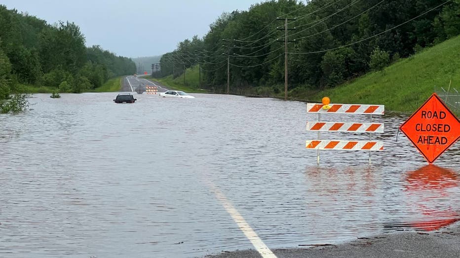
"If you do not need to travel tonight, please stay put," the sheriff's office said on Tuesday night. "There are several places on Highway 61 with water going over the road. If you have an emergency please call 911; however be advised that the call volume is currently extremely high, so if you’re only looking for information, please refrain from calling to lines open for emergencies. Updates will be posted as more information is available or as conditions change."
There have been multiple reports of flooding along Highway 61, with the sheriff's office saying it's making driving difficult and dangerous. Trees are also down along many interior roads. Multiple power outages have also been reported.
The sheriff's office also reported a 9-year-old in a tent was hit by a falling tree in the Boundary Waters Canoe Area. There's no word on how the child is doing as of this writing.