

Minnesota weather: Valentine’s Day snow moves into Twin Cities
Minnesota weather: Valentine's Day snow update
We are seeing a rare sight this winter, with some falling snow on Wednesday. Ian Leonard looks at his forecast.
MINNEAPOLIS (FOX 9) - Valentine’s Day will end lovely for those who adore the sight of falling snow in the Twin Cities.
A wide swath of the Twin Cities into southern Minnesota is experiencing a fast-moving clipper system coming from South Dakota that’s expected to leave behind anywhere from 2 to 4 inches of snow.
The further south you travel could produce pockets of larger amounts, anywhere from 4 to 6 inches from Marshall to Rochester, and east to Eau Claire, Wisconsin.
As of 6 p.m., MSP airport had reported an inch of snow while some spots saw considerably more, like Eden Valley, Minn. with 6 inches as of 6:55 p.m.
Timeline of the Valentine's Day snow
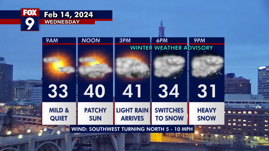
Snow is expected to begin falling around 3 p.m. on Wednesday, and continue through the early morning hours of Thursday.
Temperatures will top out in the low-40s on Wednesday, with roadways expected to begin wet, then turn to slushy and snow as the evening commute progresses.
The evening hours of 7-9 p.m. could see heavy falling snow – an uncommon sight so far this winter for much of Minnesota.
The snow should peter out by midnight.
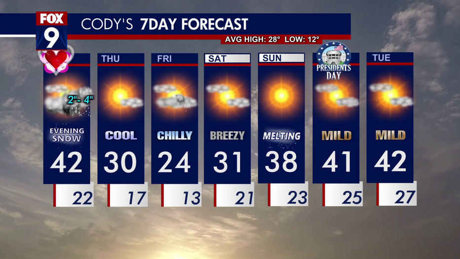
Colder Thursday
Thursday is expected to be colder, with the day beginning in the 20s, and topping out around 30 degrees, but offer sunshine and a breeze for those who venture outside.
Colder temperatures on Thursday could mean slippery roads for the morning commute.
Any snow that accumulates is expected to melt again this weekend, as highs return to the mid- to upper 30s.
Here’s your seven-day forecast:
Snow emergencies
The City of Elk River has declared a Snow Event due to inclement weather.
Overnight parking restrictions will go into effect from 2 a.m. to 6 a.m., and nightly parking restrictions will remain in effect until the snow event has been lifted by city staff.