

Minnesota weather: Final days of feeling like summer- here's how warm it'll get

Weekend warmup: Final days of feeling like summer
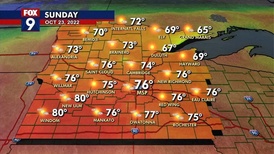
A chilly start to the day Saturday, but it will warm up and turn into a beautiful summer-like day. Sunday lows will reach around 58, with highs in the mid-70s. The warmth and humidity could lead to some strong isolated storms Sunday night.
(FOX 9) - The summer-style heat returns just in time for your weekend, with temperatures rising into the mid-70s across the Twin Cities.
Temperatures Saturday will warm quickly throughout the day after a fairly seasonable start. The highs will creep into the mid-70s and low-80s for areas along and south of the I-94 corridor on Saturday.
Southerly breezes will pick up through the day as most of the cloud cover departs to the north, leaving us fairly sunny.
There will be near record warm early morning lows on Sunday as temps only fall into the mid and upper 50s. The moisture levels will begin to soar overnight, leading to a very warm and humid day Sunday.
Sunday's high temperatures are very similar to our first weekend day but could feel significantly warmer because dew points will surge into the 50s and low 60s, making it feel more like late summer than mid-fall. It will be quite windy as gusts could top 40 mph out of the south.
Sunday will be warm and humid, with a chance of storms later in the evening (FOX 9)
The warmth and humidity could lead to some strong isolated storms Sunday night as a cold front crosses the state.
Those gusty breezes will turn out of the west and then northwest behind that front on Monday, leading to a crash in temperatures through the day. We'll likely start the day in the 60s but slide into the 50s as the day wears on, and cooler air arrives from the west.
The average last 70-degree day of the year in the Twin Cities is Oct. 23, which is Sunday. However, the average high for this time of year is 55 degrees.