

Minnesota weather: Line of storms moving through Twin Cities Wednesday afternoon
MINNEAPOLIS (FOX 9) - A line of storms is moving through the Twin Cities on Wednesday afternoon.
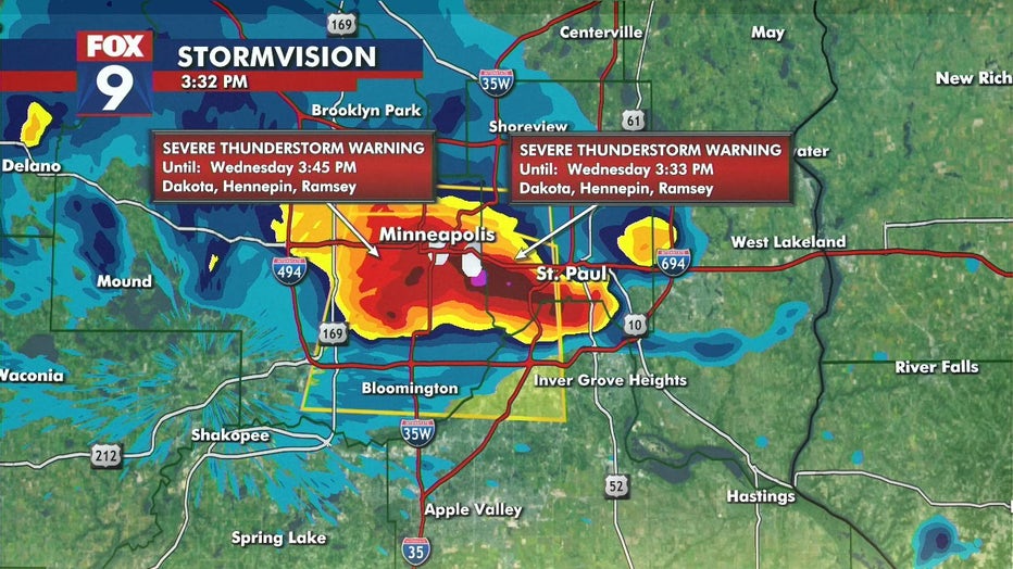
A severe thunderstorm warning was issued Wednesday afternoon for portions of the Twin Cities metro, including Dakota, Hennepin and Ramsey counties, until 3:45 p.m.
The main concerns with the storm are strong, gusty winds and hail.
Severe thunderstorm warning at 3:30 p.m. (FOX 9 / FOX 9)
The storm is moving to the south at 15 mph.
Power outages have been reported in the Twin Cities, with about 7,000 customers without power as of around 3:50 p.m., according to Xcel Energy's outage map.
The latest weather alerts can be found here.
The original story from Wednesday morning is below.
Minnesota weather: Copy and paste our warmth, isolated rumbles Wednesday
Wednesday is more of the same with sun, warmth, and isolated rumbles, but we will soon get a break from the rain as things turn steamy.
A stray rumble is possible in the morning before a brighter and warm afternoon. Much of Minnesota has temperatures in the low to middle 80s. The Twin Cities metro area has a daytime high of 84 degrees.
Isolated storms develop throughout the day in central and southern Minnesota and last into the evening. The disorganized pop-up storms could bring thunder and heavy downpours.
MN weather: Sun, more isolated rumbles Wednesday
Wednesday is almost a carbon copy of Tuesday, with sunshine, warmth, and isolated rumbles throughout the day. A stray rumble is possible in the morning with an overall bright and warm early afternoon. Isolated downpours and thunder could last into the evening. Things turn steamy and dry on Thursday.
The isolated showers fade into the evening, leaving the overnight quiet with temperatures in the mid-60s. Thursday dries out with lots of sunshine in the afternoon. Things start heating up on Thursday as dew points climb with a high of 86 degrees in the metro.
The warmth builds into the weekend, which will be hot and steamy with temperatures in the 90s. The heat index could peak close to 100 degrees on Sunday. There is a chance for storms early Saturday and late Sunday.
Here’s a look at your seven-day forecast:

(FOX 9)