

Minnesota weather: More scattered storms, still humid on Tuesday
MN weather: More scattered storms for Tuesday
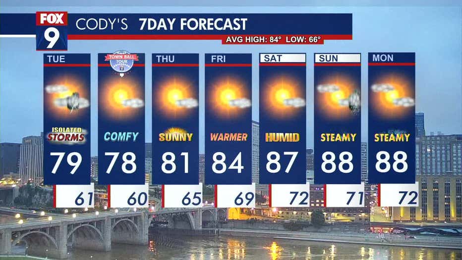
It's a gloomier Tuesday with partly to mostly cloudy skies and more rain chances. There are hit-or-miss storms in the morning, with a break in the afternoon before potential redevelopment toward the evening. Tuesday is still on the humid side with dew points in the 60s and temperatures hovering around 80 degrees.
MINNEAPOLIS (FOX 9) - Tuesday will feature hit-or-miss storms with patchy sunshine, but a break from the humidity and rain is right around the corner.
Tuesday’s forecast
A cold front is moving through, sparking showers and storms on Tuesday morning. Western Minnesota is waking up to rain and rumbles that could reach the metro by mid to late morning.
Isolated pop-up rumbles could redevelop in the late afternoon and evening with the best chances south of the I-94 corridor, but the metro cannot be ruled out.
Tuesday will have partly to mostly cloudy skies, but some sunshine will try to peek through. It’s still humid with dew points in the 60s. Temperatures are hovering right around that 80-degree mark with a daytime high of 79 degrees in the metro.
Overnight, temperatures in the metro dip into the 60s with pocket 40s in northern Minnesota.
Looking ahead to dryer conditions
A stretch of quiet weather is ahead beginning on Wednesday and lasting through most of the weekend. Wednesday is far dryer and more comfortable with a northeast breeze, lower levels of humidity, and temperatures in the upper 70s.
The southerly flow returns Thursday, bringing warmer temperatures, with a daytime high of 78 degrees. The humidity returns on Friday and into the weekend, making it downright steamy. Temperatures are in the upper 80s on Saturday and Sunday and continue into the start of the week.
Here’s a look at your seven-day forecast:
(FOX 9)