

MN weather: Severe thunderstorm watch in effect for metro, W. Wisconsin
MINNEAPOLIS (FOX 9) - 9;45 p.m. update: The National Weather Service has issued a severe thunderstorm watch for the Twin Cities and areas to the east.
The watch is in effect until 4 a.m.
8:30 p.m. update: So far the atmospheric cap has held, preventing would-be storms from forming into more severe weather in the Twin Cities area.
FOX 9 is continuing to track conditions into the evening.
--------------------------------------------------------------
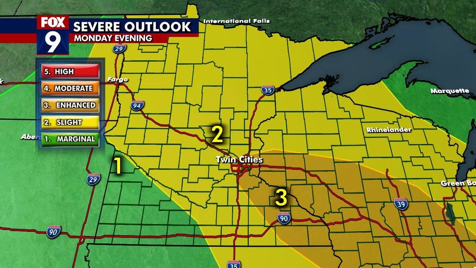
A hot and humid afternoon is setting the stage for the possibility of severe storms in the Twin Cities for Monday evening.
Parts of the region, including from the Twin Cities metro spanning to the southeast into Wisconsin, have been upgraded to a Level 3 or "enhanced" risk of severe weather.
If the storms develop, you can expect rapid intensification, as they track northwest to the southeast through the metro. The biggest risks will be strong winds, hail, downpours, flooding, and lightning, and the potential for isolated tornadoes.
That said, there is a big question mark about whether atmospheric conditions will allow the storms to form. It is like a pile of fireworks waiting for a match that might not come.
The storm risk in the metro is in effect between 7 p.m. and midnight. To the southeast, the risk could linger into the early morning hours.
(FOX 9)