

Minnesota weather: The wet weather continues

MN weather: Wet weather continues into this weekend
The heavy rain along with the frequency of our recent rain has been quite the talk around the water cooler. Especially in comparison to the last few summers, which in general, have been drier. Our forecast to finish out this week will lead to some areas picking up another 1 to 3 inches of new rainfall with locally highs amounts up to 3 to 5 inches plus.
MINNEAPOLIS (FOX 9) - The heavy rain along with the frequency of our recent rain has been quite the talk around the water cooler. Especially in comparison to the last few summers, which in general, have been drier. Our forecast to finish out this week will lead to some areas picking up another 1 to 3 inches of new rainfall with locally higher amounts up to 3 to 5 inches plus.
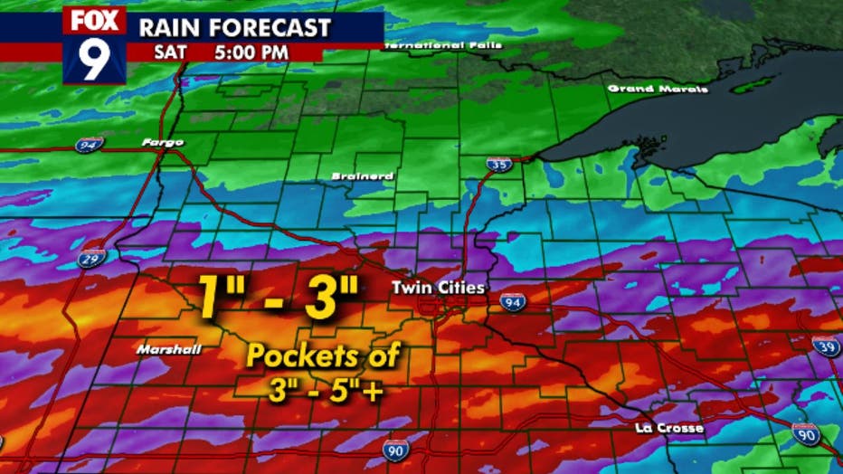
Rainfall prediction map.
This heavy rain forecast is a reminder to check your sump pump and to watch for flash flooding. Watch and listen for your sump pump to be operating properly so you don't end up with a wet basement. We've already seen videos and pictures of washed-out roads in parts of the state and with this continued wet weather to close out our work week we may see more.
Areas that may see round after round on top of saturated soils will have to watch closely for flash flooding. The flash flood risk is for Thursday and then Friday night highlighting the southern half of Minnesota to have a better chance of seeing the excessive rainfall leading to flash flooding potential. If you come across a water-covered road, turn around and don't drown. You don't know how fast the water is flowing or what is under the flowing water.
The Weather Prediction Center issues a forecast for the potential for flash flooding and significant river flooding across the U.S. It's a similar outlook that the Storm Prediction Center issues for severe weather possibilities with large hail, strong winds, and tornadoes. In this case, there is a much higher than average risk for some areas to experience flash flooding that doesn't come around all that often. At the moment, much of the southern half of the state is in a Level 3 of the four-level scale for overall risk, which we have labeled as high in the red-shaded areas. This doesn't mean that all areas will experience flooding, but it's a possibility.
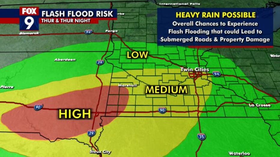
The flash flood threat for Thursday.
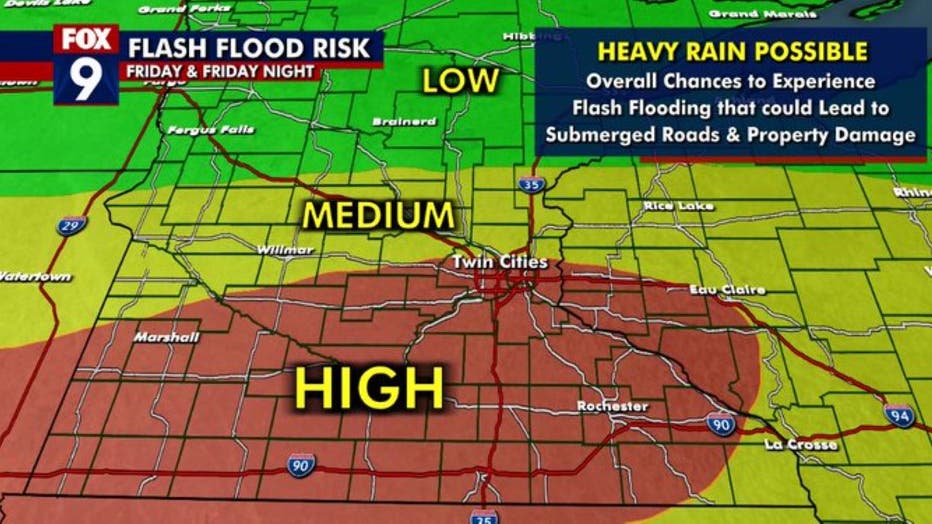
The flash flood threat for Friday. (FOX 9)
The last 90 days have been wet as we know. This has eroded away any drought we've had in the state. The map below shows the rainfall over the last 90 days. A large area of eastern and southern Minnesota has picked up anywhere from 15 to 25-plus inches of rainfall.
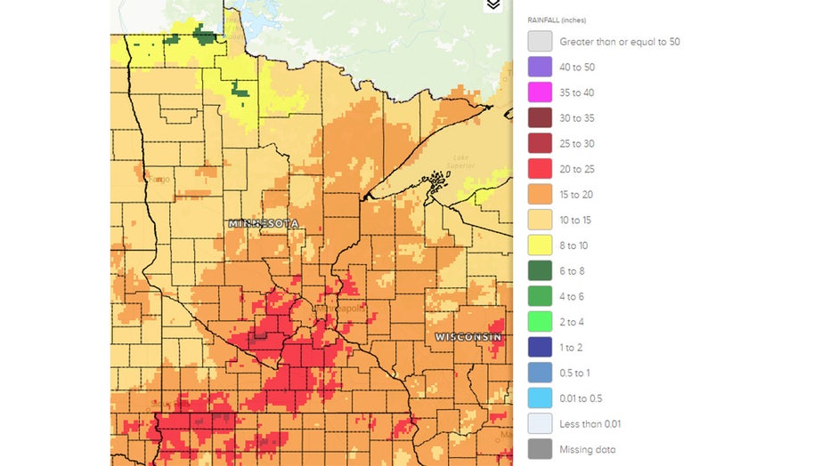
The last 90 days of rain in Minnesota.
This wet pattern we are in at the moment is setting up similarly to the summer of 2014, and June in particular. Our wettest June (and wettest month) on record was in the summer of 2014. The state-averaged monthly rainfall was 8.03 inches, which broke the previous record of 7.32 inches set in June of 1914. Some individual towns and cities picked up more than 10 inches of rain with the Twin Cities recording 11.36 inches. Glencoe received 14.24 inches, Chaska 13.24 inches, and Redwood Falls 14.24 inches were a few others recording high amounts of rainfall in June 2014.
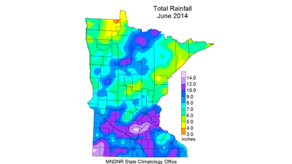
Here's a map of 2014 rainfall. (FOX 9)