

Minnesota weather: Tumbling temperatures, rain, snow and strong winds Saturday

MN weather: Tumbling temps with rain, snow Saturday
Temperatures are expected to tumble Saturday, bringing snow to the western part of the state and up into northwestern and northern Minnesota.
MINNEAPOLIS (FOX 9) - A wild Saturday forecast for the region is coming off of record-breaking high temperatures. Minneapolis-St. Paul International Airport (MSP) hit 75 degrees on Friday, and Saturday brings blizzard warnings and winter storm warnings for parts of the state as snow and strong winds bring tough travel conditions.
Saturday’s big shift
What to expect:
Temperatures will vary greatly throughout the mornings. Some areas will wake to temperatures near 50, while out west, temperatures are sub-freezing already.
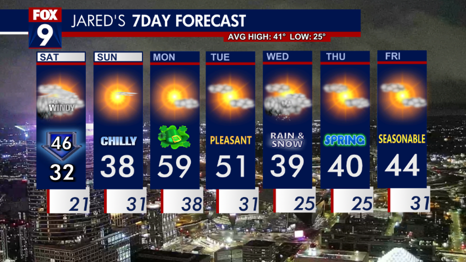
Temperatures will fall throughout the day with afternoon temperatures around the Twin Cities expected to be close to 32 degrees.
Snow and accumulating snow will fall out west and lift into parts of northern and northwestern Minnesota Saturday. Where the snow falls, some places may experience brief whiteout conditions due to very strong northwest winds.
As temperatures fall, flash freezes on roadways and other surfaces are possible. The Twin Cities metro can expect some rain/mix to possibly switch to periods of snowflakes at midday.
By Saturday afternoon, most of the precipitation will be up in northern Minnesota and slowly ushering out mid to late evening.
Start of a new week
What's next:
Behind this wild ride of Saturday’s weather, Sunday will end up being chilly and sunny.
Temperatures will stay in the 30s with a brisk morning breeze.
Temperatures will get a hefty boost on Monday with a few areas topping off over 60 degrees.
A possible quick moving wave to bring a chance of rain/snow/mix late Tuesday night into Wednesday.
Temperatures will trend a little cooler Wednesday as that system slides through.
Here is your seven-day forecast:
(FOX 9)