

Minnesota weather: Timeline for Friday's warmth and storms; Saturday snow and cold

MN weather: Warm Friday afternoon, storms into the night
FOX 9 Meteorologist Keith Marler provides an update for your Friday afternoon forecast. Friday afternoon will bring possible record-breaking warmth, with storms rolling into the state Friday night.
MINNEAPOLIS (FOX 9) - Friday brings unseasonably warm temperatures before evening storm chances, and overnight rain will transition to snow for some on Saturday.
Bright and warm Friday
Friday's forecast:
Friday could see record warmth with widespread highs in the 70s. The Twin Cities metro daytime high is expected to be around 74 degrees, just beating out the old record of 73 degrees set back in 2012.
Expect a mix of sun and occasional cloud cover ahead of the storms approaching from the south.

Storm chances Friday evening
What to expect:
There is a severe weather threat in place from Minnesota through the southern United States. Parts of central Minnesota, including the metro, are under a level one risk for severe weather, while southeastern Minnesota is under a slightly higher, level 2 risk.
These storms will be quite strong to our south in Iowa, but will be slowly weakening as they move northward. This will most likely bring a threat of strong gusty winds of 45 to 60 mph, but some quarter-sized hail and an isolated brief tornado cannot be ruled out.
Timeline of rain and snow

MN weather: Timeline for Friday's warmth, storms
FOX 9 meteorologist Cody Matz has more on what to expect with the storms on Friday and snow chances on Saturday.
Timeline:
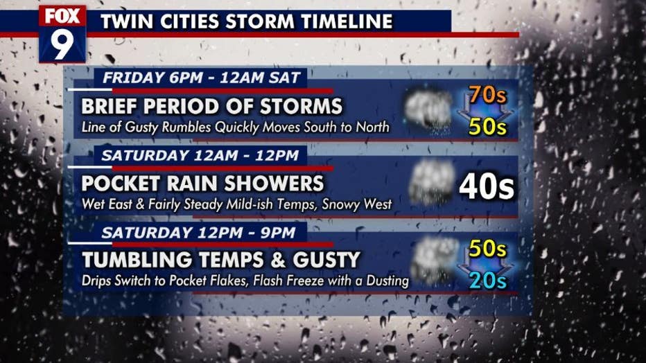
Here’s a timeline of what to expect in the Twin Cities:
- Friday 6 p.m. to Saturday at midnight: Brief periods of storms as a line of gusty rumbles quickly moves south to north.
- Saturday midnight to noon: Pocket of rain showers to the east and snowy conditions to the west.
- Saturday noon to 9 p.m.: Drips switch to pocket flurries as temperatures drop. A dusting of snow is possible in the metro.
(FOX 9)
Snow chances on Saturday
Saturday's forecast:
The Twin Cities metro will actually be relatively quiet late Friday night and through Saturday morning, though lingering light rain showers are expected.
Temperatures, though, begin to tumble by the lunch hour as gusty breezes pick up out of the northwest. Temperatures will fall through the afternoon and will likely be back below freezing by the dinner hour.
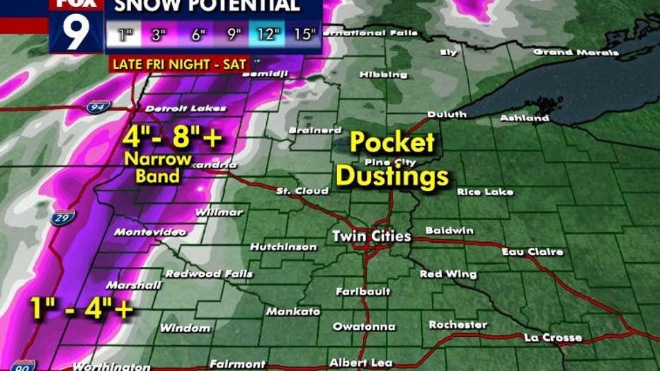
The vast majority of accumulating snow will stay well west of the Twin Cities metro. A few flakes, flurries, or snow showers could lead to a dusting or minor coating in some spots.
A winter storm watch is in effect for roughly the west quarter of the state counties, where a band of heavy snow and some gusty winds could lead to more significant accumulation and near blizzard conditions at time late Friday night through Saturday. There is an increasing potential for a very narrow (when measuring from west to east) band of snow that could bring some isolated areas of more than 6 inches.
(FOX 9)
On Sunday, conditions will start to calm as winds gradually relax, but will be chillier with highs generally in the 30s. Temperatures will then warm back into the 50s for the start of the week.
Here’s a look at your seven-day forecast:
