MN weather: First 'real' snow of the season looking likely for the Twin Cities on Thursday

MINNEAPOLIS (FOX 9) - A storm is likely to bring snow across much of Minnesota on Thursday, with several inches possible for many spots, including the Twin Cities.
Snow on Thursday
What we know: A potent Alberta Clipper will move out of Canada and into the Upper Midwest late Wednesday and into Thursday that is likely to bring a swath of several inches of snow. While this will not be anything epic, or particularly noteworthy on a grand scale, it does appear like this will be the largest snowstorm of the season for the Twin Cities so far.
Now, the bar is quite low at the moment considering the metro has yet to record the first 1-inch-plus snow day of the season. So, calling for at least an inch of snow is not exactly groundbreaking. But many of us may not have used the shovel, snow blower, or even the snow brush much so far this season, so here is your warning to get those ready for Thursday... Although admittedly, some areas likely won't get enough to use the snow blower.

What we don't know: The expected path of this storm is still very much in flux and will have implications on just how much snow the Twin Cities will receive. We also have to take into account the overall snow ratio, which is the term to describe how efficiently snow piles up with the same amount of moisture and how structures of different size snowflakes can add to the height of the snow that settles. Both moisture and snowflake structure have just as much to do with how much snow we get as does the overall path.
The moisture content and snowflake structure are the two variables that determine whether we're shoveling the heavy wet concrete type snow, the super fluffy snow, or somewhere in between. Quite likely, this will be a fluffier type snow.
Because of all of these variables, the exact expectations for snow totals have yet to come together. We'll have updates as we get closer to Thursday morning.

(FOX 9)
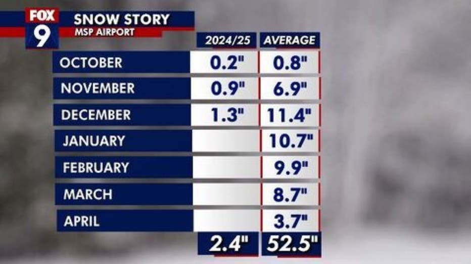
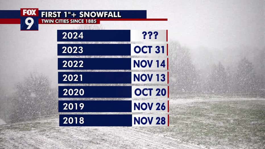
Digging deeper: The official climate site of the Twin Cities, MSP Airport, has yet to record at least an inch during a snowstorm so far this season. This is WAY behind when we typically receive it.
Now, I realize that many in the north and west metro, and much of the state really, are crying foul because there are many areas that have received an inch of snow on multiple occasions. However, that has not been recorded at the airport and therefore doesn't get recorded in our climate record. So, we still have yet to hit that threshold.
This is the latest into the season the Twin Cities metro has gone without reaching that mark since 2006, when it occurred on Dec. 21. This is easily the latest over the last several years with even a couple October appearances over the last seven years.
The metro has only made it to January without a 1-inch-plus snowstorm four times since 1885 — the record being Jan. 21, 2005.
Will the Twin Cities have a white Christmas?

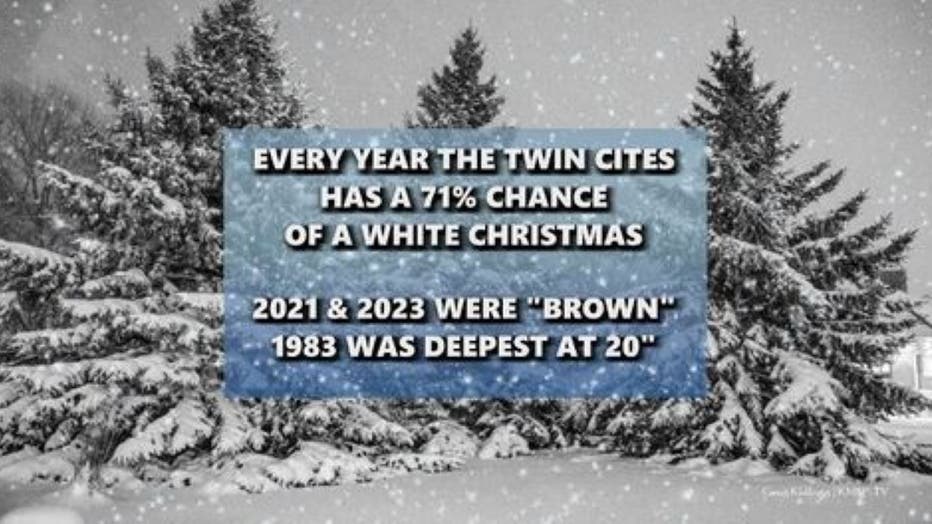
The long range: There is a really good possibility that this is the last chance to get accumulating snow before Christmas. If you want a white Christmas, then you want to wish for as much snow as possible on Thursday. This is because a large-scale pattern change is likely heading into next week, just in time for the holiday. This will set the stage for a large warming trend heading into, through, and past Christmas.
So, we may receive several inches of snow Thursday, but with above freezing temperatures possible starting Monday Dec. 23, just how much will be left on the ground for Christmas? At the moment, I would give the metro a bit better than a 50/50 chance to have snow left on the ground by Christmas morning, but it will really come down to how quickly our new snow melts going into early next week.

MN weather: Fairly cloudy, light flurries Tuesday
Tuesday will be cooler, with temperatures in the mid to upper 20s and mostly overcast skies. Later Tuesday, a clipper moving in will bring snow to southwestern Minnesota and light flurries to the Twin Cities metro. FOX 9 meteorologist Cody Matz has your forecast.

