

Warmest winter on record for Twin Cities, much of Minnesota
MN weather: Mild and breezy for Friday
It's looking like a beautiful start to March, with record warmth possible this weekend. Friday will be mild and breezy, with highs in the upper 50s for the Twin Cities metro area. By the weekend, temperatures climb into the 60s and potentially 70s, but northern Minnesota stays significantly cooler with highs in the 30s.
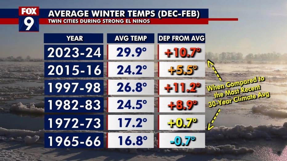
MINNEAPOLIS (FOX 9) - Our winter months are now in the rearview mirror, which means the coldest air of the year should be behind us. But it wasn't all that cold as many of us longtime Minnesotans know. We finished with an average temperature of nearly 30 degrees, making it the warmest winter months on record in the Twin Cities.
Many individual records pushed us to have such a mild winter. It was the warmest December and February. We also saw the longest January thaw, where temperatures exceeded the freeze mark in consecutive days, at 24. Not to mention we were able to enjoy the warmest February temperature on record with a high of 65 degrees, which was the second warmest winter temperature on record here in the Twin Cities metro.
But the Twin Cities and Minnesota as a whole are not the only locations that have been exceptionally warm. Many climate districts from North Dakota to Maine experienced their top 5 warmest winters. A "1" on the map below indicates the warmest winter on record, with subsequent numbers indicating how warm compared to other years dating back to 1893.
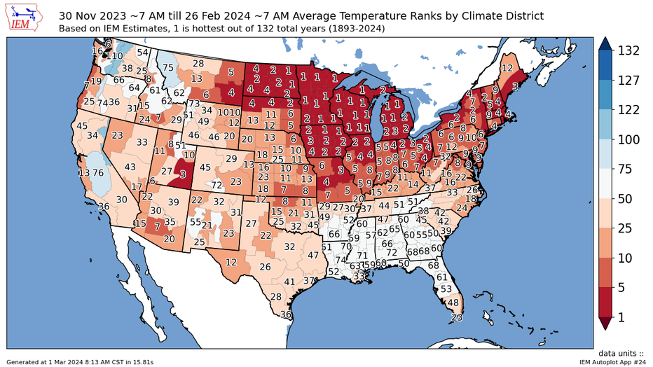
A "1" on the map indicates the warmest winter on record, with subsequent numbers indicating how warm compared to other years dating back to 1893. (FOX 9)
So, the biggest question remains, why was it so warm and will it continue? There's no clear answer to that. However, a combination of dozens of variables are likely at play with a strong El Niño as one of the largest drivers. However, other ocean oscillations are likely responsible for some of this as well, along with the large volcanic eruption in the Pacific Ocean roughly two years ago. As for the more "generic" climate change, that was also likely a factor, although there is no way to know just how much.
El Nino and temperatures.
Does any of this warmth mean we will have a really warm summer as well? The concise answer is no. There is no direct link between a warm winter and a warm (or above-average) summer. Summer temperatures are often far more affected by how much rainfall and cloud cover we see versus overall large weather patterns. However, El Niño can play a role, or lack thereof. El Niño is currently expected to dissipate rapidly, and by the summer, we could full-on swing into a La Niña. In the past where this has occurred, rain (and severe weather), become more common in the central U.S. in the spring and early summer, which can lead to slightly below-average temperatures. But of course, it's necessary to say that we don't know for sure, and many things could change between now and then.