

Winter blast plunges North Carolina, Tennessee into freeze after Hurricane Helene
Recovery continues in North Carolina after Helene
Nearly three weeks after Helene swept through the Southeast, many communities are still reeling from its impacts as the extent of its devastation is coming into focus. At least 251 people are dead from Helene's devastation across seven states. Ryan Cole, the Assistant Emergency Services Director for Buncombe County, North Carolina joined LiveNOW from FOX's Josh Breslow to talk about recovery efforts.
ASHEVILLE, N.C. - The weather has been cooperating in areas of western North Carolina and eastern Tennessee since the region was slammed by Hurricane Helene weeks ago, but a cold front that blasted through the region this week has sent temperatures tumbling and flakes flying in the higher elevations.
The change in the weather has only added insult to injury for residents in areas that are still waiting for their power to be restored while work continues to clear debris and try to locate the more than 90 people who remain missing since the deadly hurricane.
Freeze Warnings and Frost Advisories have been issued across western North Carolina due to the falling temperatures, which is no doubt having an effect on residents who remain without power.
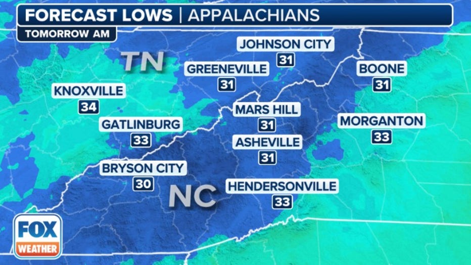
This graphic shows forecast low temperatures on Thursday, Oct. 17, 2024. (FOX Weather)
Morning low temperatures are expected to plunge into the low 30s and daytime high temperatures will struggle to get out of the 50s, which the FOX Forecast Center said is more reminiscent of December and January, not mid-October.
While temperatures fall, some communities in the higher elevations even saw their first snowfall of the season.
Video recorded in Johnson County, Tennessee, showed snow falling from the sky overnight while another video showed graupel covering roads and sidewalks.
The cold weather is expected to peak by Thursday, which means Asheville, North Carolina, will be flirting with its record-low temperature of 31 degrees for that date.
According to the FOX Forecast Center, temperatures are expected to rebound and rise back toward average over the weekend.
Read more of this story from FOX Weather.