What caused the California fires? What we know
A rare combination of risk factors in Los Angeles County has sparked a series of deadly wildfires that have destroyed thousands of homes and businesses.
The exact death toll remained unclear Friday morning – at least 10 people have died – but the total is expected to rise as crews begin to search the rubble.
RELATED: California fires map: Los Angeles evacuation orders, warnings
Roughly 380,000 people in Southern California were under evacuation orders or warnings by Thursday, while hundreds of thousands remained without power.
AccuWeather estimated $52 billion to $57 billion in preliminary damage and economic loss has occurred from the fires.
What caused the fires?
The exact cause of each fire is still under investigation, but officials have largely blamed the extreme drought conditions, combined with the supersized Santa Ana winds whipping flames and embers at 100 mph – much faster than usual.
RELATED: All LAUSD schools closed Thursday, Friday as fires continue to rage across LA County
Add on weather whiplash that grew tons of plants in downpours, then record high temperatures that dried them out to make easy-to-burn fuel. Then there’s a plunging and unusual jet stream, and lots of power lines flapping in those powerful gusts.

Flames from the Palisades Fire burn a building on Sunset Boulevard amid a powerful windstorm on January 8, 2025 in the Pacific Palisades neighborhood of Los Angeles, California. (Photo by Apu Gomes/Getty Images)
Experts say that’s what is turning wildfires into a deadly urban conflagration.
The winds dropped Thursday, but the National Weather Service warned that even the reduced gusts could still spread fire rapidly and the wind is expected to strengthen again Thursday evening. Another round of strong winds may form Tuesday.
Santa Ana winds
The Santa Ana winds are dry, powerful winds that blow down the mountains toward the Southern California coast.
The region sees about 10 Santa Ana wind events a year on average, typically occurring from fall into January. When conditions are dry, as they are right now, these winds can become a severe fire hazard.
The Santa Ana winds occur when there is high pressure to the east, in the Great Basin, and a low-pressure system off the coast. Air masses move from high pressure to low pressure, and the more extreme the difference in the pressure, the faster the winds blow.
Topography also plays a role.
RELATED: Paris Hilton, Jamie Lee Curtis, Billy Crystal among celebs who lost homes in LA wildfires
As the winds rush downslope from the top of the San Gabriel Mountains, they become drier and hotter. That’s a function of the physics of air masses. By the time the winds get to the point where the Eaton Fire broke out in Altadena on Jan. 7, it’s not uncommon for them to have less than 5% relative humidity, meaning essentially no moisture at all.
Winter fires vs. summer fires
Fires don’t usually blaze at this time of year, but specific ingredients have come together to defy the calendar in a fast and deadly manner.
RELATED: Lakers game postponed amid LA wildfires: 'We're with you, LA'
Summer fires are bigger usually, but they don’t burn nearly as fast. Winter fires "are much more destructive because they happen much more quickly" said U.S. Geological Survey fire scientist Jon Keeley.
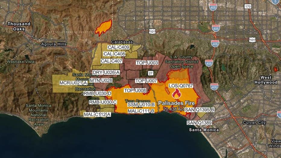
Palisades Fire

Screen shot of map taken on Jan. 9, 2025, from Cal Fire's website at 2:46 a.m. PT.
Acres burned: 17,234
Thousands of structures have been damaged or destroyed in Pacific Palisades, making it the most destructive fire in Los Angeles history.
RELATED: Palisades Fire: Human remains believed to be found in rubble near Malibu
Many residents who refused to evacuate suffered serious injuries, fire officials said.
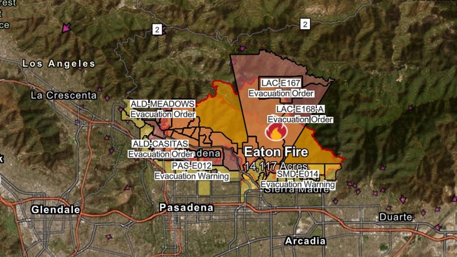
Eaton Fire

Screen shot of map taken on Jan. 9, 2025, from Cal Fire's website at 2:47 a.m. PT.
Acres burned: 10,600
The Eaton Fire was first reported near Atladena and Midwick just after 6:15 p.m. on Tuesday.
Five people have died and a significant number of people were injured, officials said on Wednesday.
On Thursday, officials said that the Eaton fire was at 10,600 acres, but that growth has significantly stopped.
It's currently 0% contained, and more than 1,000 structures have been damaged and destroyed.
Sunset Fire

Last updated at 12:11 p.m. on Jan. 9, 2025.
Acres burned: 43
The Sunset Fire was fully contained as of 11:30 a.m. Wednesday, according to Los Angeles Mayor Karen Bass. Evacuation orders were lifted.
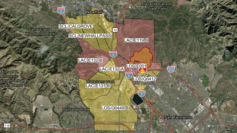
Hurst Fire

Last updated at 01/09/2025 4:45 AM.
Acres burned: 855
The Hurst Fire was first reported at about 10:30 p.m. on Tuesday in the 5900 block of Yarnell Street.
It was 100% contained by Wednesday evening.
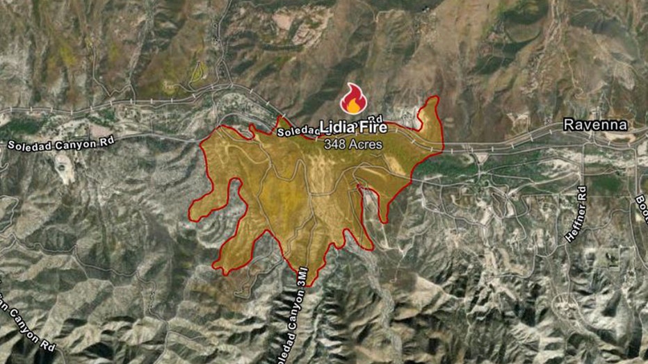
Lidia Fire

Screenshot updated at 01/09/2025 4:05 AM.
Acres burned: 348
The Lidia Fire was first reported at about 2:12 p.m. on Wednesday afternoon near the 5700 block of Soledad Canyon Road in Acton, according to CalFire.
While the Lidia Fire is significantly smaller than the other larger fires burning across Los Angeles County, it has prompted evacuation warnings and orders across a large swath of zones.
The Lidia Fire was 60% contained as of midday Thursday, officials said.


