MN weather: First snow of the season in the Twin Cities metro

Slushy start to Halloween in Twin Cities
Snow is flying areas of the Twin Cities metro Thursday morning, which will lead to a damp, slushy Halloween for some. FOX 9's Se Kwon is tracking the weather in Hutchinson at 7 a.m. on Oct. 31, 2024.
MINNEAPOLIS (FOX 9) - The first snowflakes of the season arrived on Halloween for some in the Twin Cities metro.
Snow falling in Twin Cities metro area
Snow is flying in areas of the Twin Cities metro and central Minnesota on Thursday, which will lead to a damp and slushy Halloween for some. A winter weather advisory is in place through part of the day due to potentially heavy snowfall rates that could lead to low visibility, making travel difficult at times.
As temperatures continue to slowly slide, the rain mixes with snow, leading to white flakes being spotted in southeastern and central Minnesota. While the snow accumulates in grassy areas for some, it will be more of a slushy mess for others. Some have reported downed tree branches from the heavy snow.
There are many variables working against widespread snow accumulation, like very warm ground, temperatures that are likely to stay above freezing, and heavy rain beforehand, just to name a few.
However, there are likely to be patchy areas that receive anywhere from 1 to 3 inches of slushy slop on grassy and colder surfaces. But totals will likely vary drastically over short distances.
Share your snow photos with us. See snow photos and upload them here.
Power outages across Twin Cities
Thousands of customers lost power in the Twin Cities, St. Cloud and western Wisconsin during the snow on Thursday, including at Wayzata High School and Champlin High School. Here's the latest.
Snow totals
Snowfall totals through 11 a.m. indicates areas west of the metro, such as Dassel, received at least 2.5 inches of snow.
Meanwhile, Maple Plain in Hennepin County received an inch of snow.
Areas in southwestern Minnesota, like the City of Windom, received 2.4 inches of snow on Thursday morning.
Hinckley, in Pine County, received an inch of snow.
"These totals are instantaneous because the temperatures are above freezing, so as soon as the snow tapers to flurries or slows down, it's actively melting and will compress and disappear rather quickly," explains FOX 9 meteorologist Cody Matz.
When is the typical first measurable snowfall in the Twin Cities?
This rain-snow mix is showing up right on time.
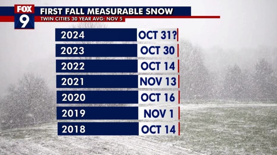
The average first measurable snowfall in the Twin Cities, according to the 30-year average, is Nov. 5. The chart above shows the first measurable snow in recent years, with measurable snow first falling on Oct. 30 last year and on Oct. 14 in 2022.

The first measurable snow fall in the Twin Cities for the past several years. (FOX 9)
History of Halloween snow
The first measurable snowfall typically happens around the start of November, which is why the Twin Cities has certainly seen snow on Halloween before.
The most notable snowfall was the 1991 Halloween Blizzard, when 8.2 inches of snow fell on the holiday itself, and a whopping 28 inches fell over a three-day span. This remains the largest snow storm in Twin Cities history.
Measurable snow has been recorded just seven times on Halloween since 1872 in the Twin Cities, which is actually quite lucky considering the first measurable snow each year is often within a few days of the holiday. It probably seems more unusual this year because of how warm it's been as of late, but our short memories may forget that we had measurable snow on Halloween just last year.
In fact, 2023 was the second-snowiest Halloween on record. Snow clearly isn't ideal for trick-or-treat festivities, but rain may arguably be worse from a celebratory and costume standpoint. There have been roughly 30 other years that have recorded rainfall on Halloween.

History of Twin Cities Halloween snow
It's been a weather whiplash week in Minnesota. Tuesday had a record high with temperatures just shy of 80 degrees, and two days later, the first snow of the season will fall on Halloween. However, snow on Halloween isn't necessarily uncommon. FOX 9 meteorologist Keith Marler has more on the Twin Cities snowiest Halloween's.

