Minnesota weather: Snow and rain combo will decorate our Halloween
MINNEAPOLIS (FOX 9) - Get ready for a chilly and wet Halloween in the Twin Cities, with rain and snow expected to last through the evening.
Share your snow photos with us. See snow photos and upload them here.
Halloween snow forecast
RELATED: MN weather: First snow of the season in the Twin Cities metro
Prepare for a cold and wet Halloween with a rain-snow mix in the Twin Cities, and measurable snow in some areas. Here’s a timeline of what to expect in the metro.
- Morning: Areas of rain, heavy at times with some thunder possible, making for a wet commute, as temperatures slide into the upper 30s.
- Late morning to early afternoon: Temperatures continue slowly sliding, dropping into the mid-30s. This is when the rain will begin to mix with snow or changeover to some large flakes at times. The snow will have a bursty nature to it, meaning it could be rather intense at times as it busts through some of the rainfall.
- Late afternoon through the evening: The wintry mix will gradually taper off from southwest to northeast, with the combo likely exiting the metro by sunset around 6 p.m., just in time for the majority of us to have drier evening festivities including trick-or-treating.
- Overnight: Things are calmer but still damp and cold as temperatures dip into the upper 20s and 30s for much of Minnesota.
Winter weather advisory
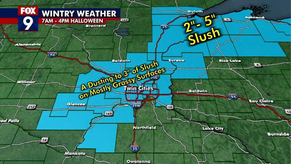
A winter weather advisory is in effect for parts of the metro and central Minnesota from 8 a.m. to 4 p.m and lingering longer, through 7 p.m. for areas toward Lake Superior. The advisory was not issued because of overall expected snow totals.
However, because of the bursty nature to this snow, snowfall rates could be quite heavy at times, which will lead to very low visibility, making driving and traveling a little more difficult in some periods, despite the fact that roadways will likely just be wet and not white.

(FOX 9)
How much snow could we get?
So, just how much snow could we get? It's complicated. There are many variables working against widespread snow accumulation, like very warm ground, temperatures that are likely to stay above freezing, and heavy rain beforehand, just to name a few.
However, there are likely to be patchy areas that receive anywhere from 1 to 3 inches of slushy slop on grassy and colder surfaces. But totals will likely vary drastically over short distances. For example, your house may only get a dusting, but the hill down the street may be slightly cooler, so a couple of inches accumulate there.

(FOX 9)
History of Halloween snow
The first measurable snowfall typically happens around the start of November, which is why the Twin Cities has certainly seen snow on Halloween before.
The most notable snowfall was the 1991 Halloween Blizzard where 8.2 inches of snow fell on the holiday itself, and a whopping 28 inches fell over a three-day span. This remains the largest snow storm in Twin Cities history.
Measurable snow has been recorded just seven times on Halloween since 1872 in the Twin Cities, which is actually quite lucky considering the first measurable snow each year is often within a few days of the holiday. It probably seems more unusual this year because of how warm it's been as of late, but our short memories may forget that we had measurable snow on Halloween just last year.
In fact, 2023 was the second snowiest Halloween on record. Snow clearly isn't ideal for trick-or-treat festivities, but rain may arguably be worse from a celebratory and costume standpoint. There have been roughly 30 other years that have recorded rainfall on Halloween.
History of Twin Cities Halloween snow
It's been a weather whiplash week in Minnesota. Tuesday had a record high with temperatures just shy of 80 degrees, and two days later, the first snow of the season will fall on Halloween. However, snow on Halloween isn't necessarily uncommon. FOX 9 meteorologist Keith Marler has more on the Twin Cities snowiest Halloween's.
Looking ahead
Things heat up slightly on Friday with highs in the upper 40s and a mostly cloudy afternoon. By the weekend, temperatures are back to the upper 50s, with a possible return to the 60s by Monday.
We get a break from the rain at the end of the week before our next chance of showers arrives on Sunday and Monday.
Here’s a look at your seven-day forecast:

(FOX 9)

