

MN weather: Pleasant Tuesday with a stray late day drip
Minnesota weather: Cooler temps ahead, maybe some rain?
Temps are shifting towards colder temperatures this week and maybe, finally, some rain. Cody Matz has your forecast.
MINNEAPOLIS (FOX 9) - A warm and sunny Tuesday is in the forecast before temperatures tumble for Wednesday.
There's also the potential for some scattered showers in the Twin Cities this week.
Tuesday's forecast
The high on Tuesday will be around 75 degrees with sunshine, but cooler across northern Minnesota.
Scattered showers are possible along the Canadian border Tuesday afternoon, and as the system scoots through it could lead to drips just north of the Twin Cities by around the dinner hour.
After the system moves through, a cold front will hit and northwest breezes kick in, causing temperatures to tumble pretty quickly Tuesday evening and Tuesday night.
Looking ahead: Chance for scattered showers
It will be much cooler Wednesday morning compared to Tuesday morning but still slightly above average for this time of year. The temperature early Wednesday is forecast to be around 44 degrees for the Twin Cities.
Cloud cover will disappear, making for a perfectly seasonable Wednesday afternoon with plenty of sunshine. But it'll be much cooler than Tuesday, with most highs in the 50s.
The next little system starts to rise on Thursday. It will be a bit warmer, with highs somewhere in the 60s but it may bring the first chance for scattered showers in the Twin Cities in a very long time. As of Tuesday, the Twin Cities have gone 32 consecutive days without a single drop of recorded rain at Minneapolis-St. Paul International Airport.
Looking ahead to this weekend, highs in the upper 50s are in the forecast for the Twin Cities with plenty of sunshine. We could see 70 degrees again on Monday.
Here's the seven-day forecast:
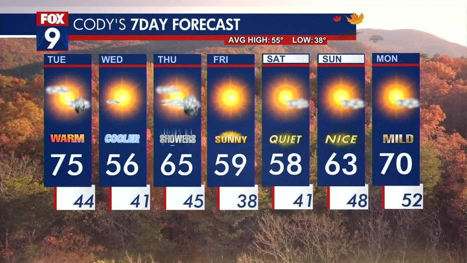
The seven-day forecast. (FOX 9)