Possible rain-snow mix for the Twin Cities on Halloween showing up right on time
MN weather: Possible rain-snow mix Thursday
It's a warm start Wednesday morning with temperatures in the 70s, but temperatures continue to drop into the 50s. Showers are likely later on Wednesday ahead of widespread rain arriving overnight, which will turn into a rain-snow mix early Thursday morning. FOX 9 meteorologist Cody Matz has your forecast.
MINNEAPOLIS (FOX 9) - A rain-snow mix is possible on Halloween, with snow in the forecast for the Duluth area and northwestern Wisconsin.
Rain, snow on Halloween
Widespread rain will roll into the Twin Cities metro late Wednesday evening, developing from the south and southwest.
It will be all rain to start, and then it will shift to a rain-snow mix. This may lead to some straight-up snow north of the Twin Cities, from Pine County north toward Duluth and northwestern Wisconsin, on Thursday morning, where a winter storm watch is in effect. A few inches of snow is possible in these areas — especially on the colder, grassier surfaces.
For the Twin Cities metro area, it'll be mostly rain with some snowflakes maybe mixing in at times. A dusting of snow on the grass, rooftops, or decks is possible, but it is unlikely to affect roadways.
READ MORE: Twin Cities set new high temp record on Tuesday
Trick-or-treating forecast
The good news is the precipitation on Thursday morning will be done by Thursday evening. It won't actively be raining or snowing, but things will be damp.
Temperatures will top out in the lower 40s on Halloween afternoon before dropping into the 30s during the evening.
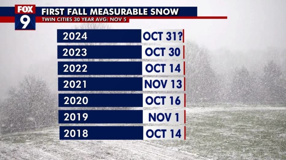
When is the first measurable snow fall in the Twin Cities?

The first measurable snow fall in the Twin Cities for the past several years. (FOX 9)
The rain-snow mix forecast for Halloween is showing up right on time.
The average first measurable snow fall in the Twin Cities, according to the 30-year average, is Nov. 5. The chart above shows the first measurable snow in recent years, with measurable snow first falling on Oct. 30 last year and on Oct. 14 in 2022.
Looking ahead
After highs in the 40s on Halloween, temperatures will climb back into the 60s this weekend.
Some wet weather is possible on Sunday and Monday, with showers in the forecast.
Here's your seven-day forecast:

(FOX 9)

