Beta weakens into tropical depression, brings dangerous flash flooding to Texas

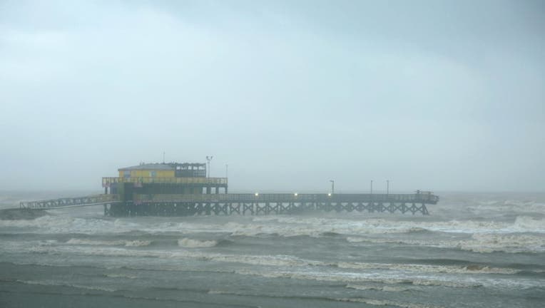
Strom clouds are seen at Galveston Island as Tropical Storm Beta will make landfall near Matagorda Bay on September 21, 2020 in Galveston, Texas. (Photo by Zeng Jingning/China News Service via Getty Images)
HOUSTON (AP) - Beta weakened to a tropical depression Tuesday as it parked itself over the Texas coast, raising concerns of extensive flooding in Houston and areas farther inland.
Beta made landfall late Monday as a tropical storm just north of Port O’Connor, Texas, and has the distinction of being the first time a storm named for a Greek letter made landfall in the continental United States. Forecasters ran out of traditional storm names last week, forcing the use of the Greek alphabet for only the second time since the 1950s.
By mid-morning Tuesday, Beta was 15 miles (25 kilometers) east-northeast of Victoria, Texas, with maximum sustained winds of 35 mph (55 kph), the U.S. National Hurricane Center said. The storm was moving toward the northeast at 2 mph (4 kilometers) and is expected to stall inland over Texas through Wednesday.
The National Weather Service said areas south and east of Houston had already seen 10 inches (25 centimeters) or more of rain by midday Tuesday because of Beta.
RELATED: Tropical Storm Beta makes landfall in Matagorda Bay Peninsula
Street flooding was reported in parts of Houston, but there were no reports of buildings being flooded, Mayor Sylvester Turner said late Tuesday morning. Turner urged residents to stay home and, if they couldn't, to not drive around the 70-some barricades placed throughout the city.
“It's going to be moving very slowly heading east and until it clears and gets on the east side of Houston, we’re going to have to deal with these rain bands,” Turner said.
Beta was the ninth named storm that made landfall in the continental U.S. this year. That tied a record set in 1916, according to Colorado State University hurricane researcher Phil Klotzbach.
Beta was expected to eventually move over Louisiana, Arkansas and Mississippi later in the week, bringing the risk of flash flooding.
Forecasters warned of heavy rainfall Tuesday on the middle and upper Texas coast, which will cause significant flash flooding. Six to 12 inches of rain (15 to 30 centimeters) was expected, with some isolated areas of up to 20 inches (51 centimeters), forecasters said.
However, forecasters and officials reassured residents Beta was not expected to be another Hurricane Harvey or Tropical Storm Imelda. Harvey in 2017 dumped more than 50 inches (127 centimeters) of rain on Houston, causing $125 billion in damage in Texas. Imelda, which hit Southeast Texas last year, was one of the wettest cyclones on record.
Gov. Greg Abbott issued a disaster declaration for 29 Texas counties on Monday, ahead of Beta’s arrival.
Beta is forecast to dump heavy rain on the southwestern corner of Louisiana three weeks after the same area got pounded by Hurricane Laura. The rainfall and storm surge prompted Louisiana Gov. John Bel Edwards to declare a state of emergency.
In Lake Charles, Mayor Nic Hunter worried about Beta’s rainfall could set back efforts in his Louisiana community to recover after Laura, which damaged about 95% of the city’s 30,000 structures. Hunter said the worry of another storm was “an emotional and mental toll for a lot of our citizens.”
Parts of the Alabama coast and Florida Panhandle were still reeling from Hurricane Sally, which roared ashore Wednesday, causing at least two deaths.
Meanwhile, Hurricane Teddy continued its path toward Canada, with a predicted landfall in Nova Scotia early Wednesday before moving into Newfoundland on Wednesday night, forecasters said. The large and powerful storm was causing dangerous rip currents along the U.S. East Coast, and tropical storm conditions were expected to begin in Nova Scotia by Tuesday afternoon, the hurricane center said.
Teddy was about 345 miles (555 kilometers) south of Halifax, Nova Scotia, on Tuesday morning with maximum sustained winds of 105 mph (165 kph). Teddy was expected to weaken later Tuesday and Wednesday but forecasters said it would likely be a strong, post-tropical cyclone when it moves in and over Nova Scotia.
RELATED: Hurricane Alpha? Active hurricane season may run out of names
Paulette, which made landfall last week in Bermuda as a hurricane, has regenerated near the Azores but was weakening on Tuesday, the hurricane center said. Now a tropical storm, Paulette was expected to become a post-tropical remnant low in the next day or so.
The National Weather Service said on Twitter: “Because 2020, we now have Zombie Tropical Storms. Welcome back to the land of the living, Tropical Storm Paulette.__
Associated Press reporters Seth Borenstein in Kensington, Maryland, and Janet McConnaughey and Rebecca Santana in New Orleans and Julie Walker in New York City contributed to this report.

