

Minnesota weather: Turning more humid, record warmth possible Monday
MINNEAPOLIS (FOX 9) - It’s going to be a breezy and bright day with record warmth possible on Monday.
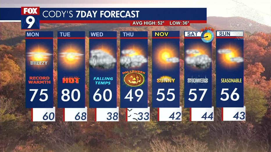
Monday forecast
Above-average temperatures kick off the week, thanks to southerly winds bringing in warmer air. Expect gusty conditions with winds of 10-20 mph and gusts reaching up to 35 mph at times. The shift in winds is also raising dew points, hitting the upper 50s and potentially creeping into the 60s, setting the stage for a warmer couple of days.
The Twin Cities metro high is forecast to reach 75 degrees on Monday, which would match the record set in 1948. Northern Minnesota will have cooler temperatures in the 50s and 60s. High clouds will drift through on Monday, creating filtered sunshine.
Overnight, temperatures remain warm with widespread lows in the upper 50s and lower 60s for the metro and southeastern Minnesota.
Looking ahead
Temperatures remain warm on Tuesday with a high of 80 degrees for the metro and areas south. Meanwhile, northern Minnesota is much cooler with highs in the 50s, and the area could see scattered showers.
A cold front moves in on Wednesday, bringing another chance for scattered showers in northern Minnesota, with some rain and storms possibly reaching the metro and eastern Minnesota by the afternoon. The rain may linger into Thursday morning, but should dry up in time for trick-or-treating on Halloween.
Here's a look at your seven-day forecast:
(FOX 9)