

Red flag warning issued for areas of western Minnesota
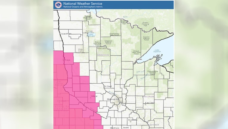
The NWS red flag warning map on Oct. 16, 2024. (Supplied)
ST. PAUL, Minn. (FOX 9) - A red flag warning has been issued on Wednesday in parts of southwest and west central Minnesota due to an extreme fire risk.
The National Weather Service issued a warning for 27 counties due to the "extreme fire danger." The alert states that very dry conditions, lower humidity, and stronger winds create "red flag fire weather conditions" for part of Wednesday.
Which counties are affected?
The warning is effective from 1 p.m. to 7 p.m. in 27 counties. Those counties include Big Stone, Brown, Chippewa, Clay, Cottonwood, Douglas, Grant, Jackson, Kandiyohi, Lac Qui Parle, Lincoln, Lyon, Martin, Murray, Nobles, Otter Tail, Pipestone, Pope, Redwood, Renville, Rock, Stevens, Swift, Traverse, Watonwan, Wilkin, and Yellow Medicine.
What is a Red Flag warning?
The Minnesota Department of Natural Resources (DNR) said a red flag warning means that "fires can spread quickly and easily progress out of control under the predicted weather conditions, including gusty winds and low relative humidity. Do not burn in counties where a Red Flag Warning is in effect and check any recent burning to ensure the fire is completely out."
When a red flag warning has been issued, the DNR will not issue or activate open burning permits, and campfires are discouraged.
Fire danger and burning restrictions
Much of Minnesota is at a "very high" fire danger risk, meaning that fires can start easily and spread at a very fast rate. Sections of southeastern and northwestern Minnesota are at a "high fire risk," while northern Minnesota is at a "moderate" fire risk, according to the DNR website.
Meanwhile, much of the state has some sort of burning restrictions in place. Portions of northeastern Minnesota have elevated burning restrictions, meaning no open burning is allowed and additional restrictions as needed based on the current fire danger.
For more information about the current statewide fire danger and burning restrictions, visit the Minnesota DNR's website.